Index
Nebr. Map
Wyo. Map
Utah Map
Cal-Nev Map
Trail Links
Home
Journal of Western Travel
by John McTurk Gibson
edited by Weldon Hoppe
June 14th, 1859 -- Dry and dusty, saw more dead cattle today than we have seen on the trip. Passed any amount of Indian lodges, reached and crossed Laramie's Fork on a toll-bridge, $2.50 per team.
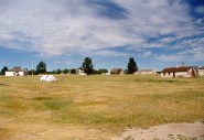
 Went into Fort Laramie Reserve, 3 miles square, quite a pleasant place, houses comfortable, nicely whitewashed and cleanly looking. We are not 3 mile beyond the Fort, no one being permitted to camp inside the Reserve.
Powell